Daily Spark / News - Second Semester
January 6, 2014
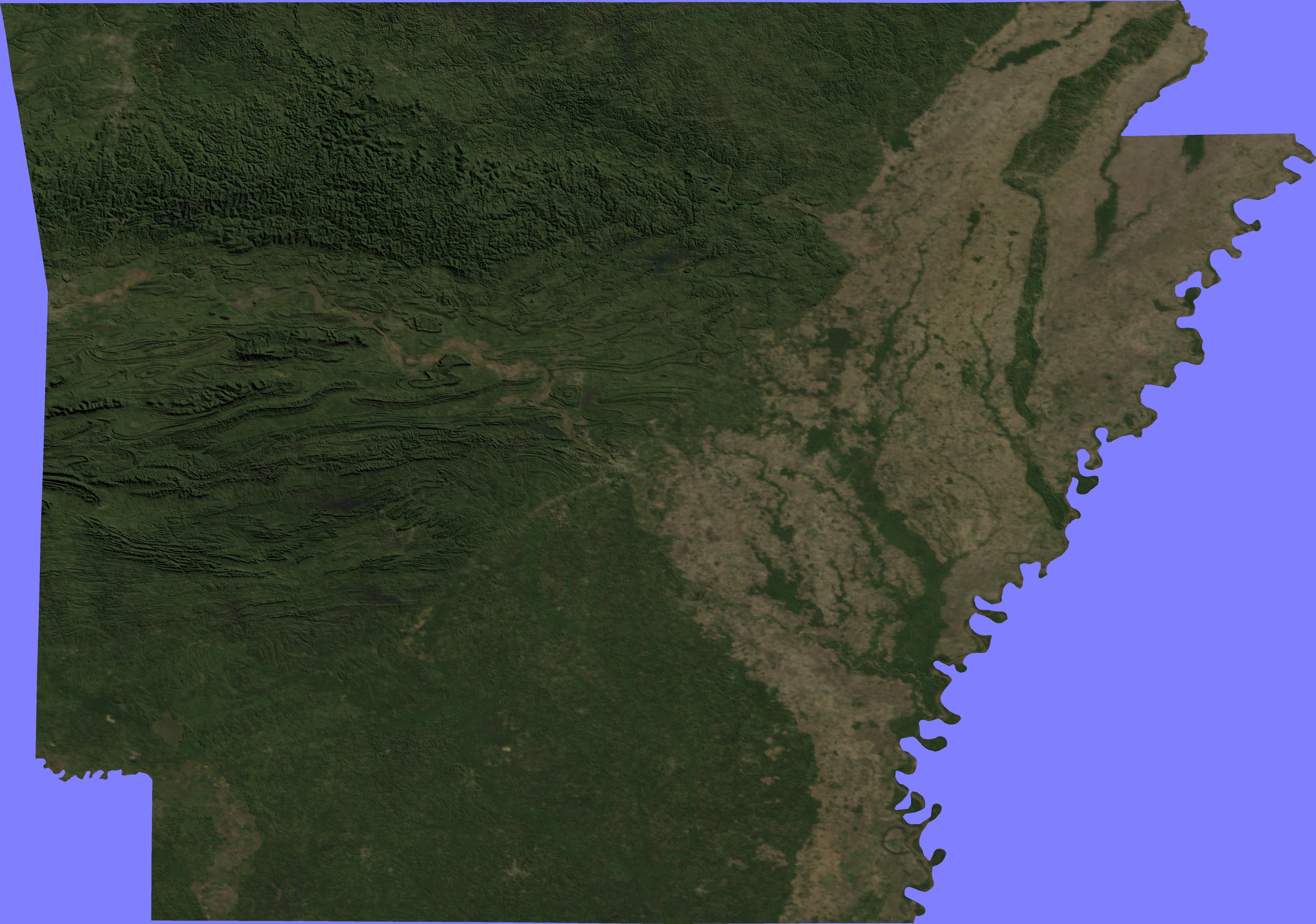
1. Your Daily Sparks will one change for this semester. On occasion (often, actually), you'll have a link to a map that you'll need to answer some questions about. Most of these Daily Sparks (with the maps) are graded for accuracy, so really make sure you're correct and that you answer all questions using any available means. For your first Daily Spark of 2014, we'll start with this 1972 map of Arkansas. List a county on the northern border of the state, a county on the southern border of the state, a county on the western border of the state, and a county on the eastern border of the state.
January 7-8, 2014
2. Our class calendar for second semester is now posted under the Calendar tab. Also, for those of you that find yourselves frequently bored and wishing to learn more about examples of U.S. citizens' interpretations of civil disobedience in the "modern" era of U.S. history, here is a fascinating interview. When was the last time you used a map? What was it for? Were you successful in your interpretation of the map for its purposes? Do not include any instances of GPS usage.
January 9, 2014
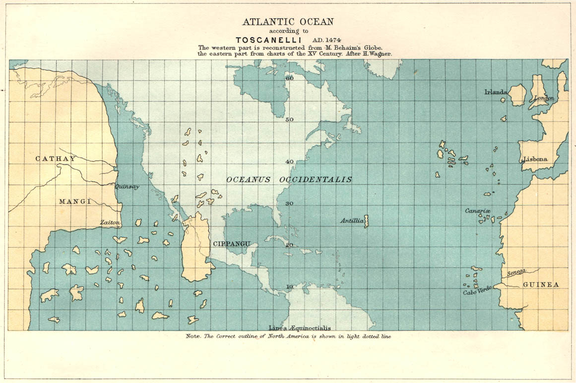
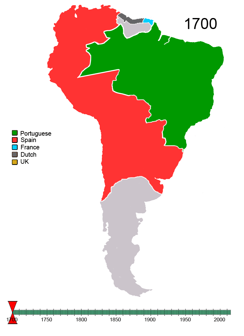
3. Take a look at this map. Who do you think made it? What is it? What do you think it was for? Why are the modern North/South American continents superimposed into the background, do you think?
January 10-13, 2014
4. Is this map political, physical, or thematic? What do you think this map is about?
January 13-14, 2014
5. According to this map, how many counties in Arkansas have a median household income of $52,000 or above? How many counties on the Texas border with Mexico DO NOT have a median household income of more than $35,000? Lastly, see if you can find these prominent urban areas, even without any indicators on this map: Chicago (IL), Dallas (TX), Houston (TX), Nashville (TN), Atlanta (GA), Washington (DC), San Francisco (CA).
January 15, 2014
6. In 2-3 sentences (not 1), how does Earth axis and tilt affect the seasons in Arkansas?
January 16-17, 2014
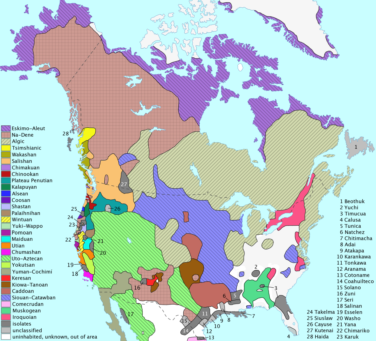
7. Study this map of Native American language families before the arrival of Europeans. What are the three most widely used, in terms of land area, language families?
January 21, 2014
8. Take a look at the picture on page 79 of your textbook. How old do you think that phone is?
January 22-23, 2014
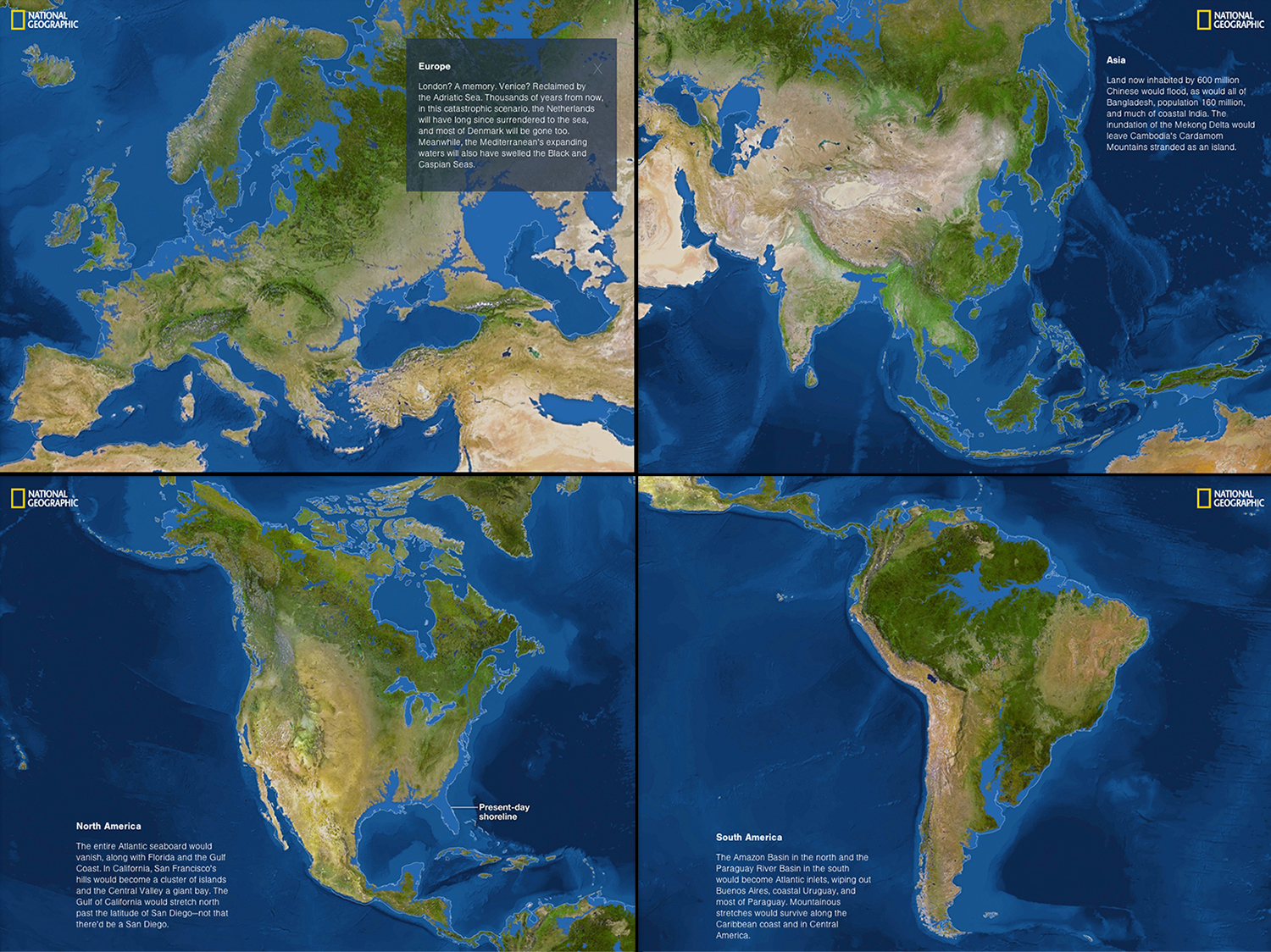
9. This is a map of what the Earth may look like after global warming melts a ton of polar ice. Would Little Rock be under water? What about Pine Bluff? If you cannot tell, find another map with those cities on it and compare the two.
January 23-24, 2014
10. Study up, son! Your test will start in 6 minutes.
January 27, 2014
11. Make one decision and choose between this link and this link. You can only pick one, do not go back and choose the other. Don't be wise and try to tip off your friends/classmates about which link is which, I will be changing them (...or will I?). After you've chosen, answer this: In your own words, what do you see? What is it? Work on your writing efficiency in your Daily Sparks. Some of your Daily Sparks are getting quite lazy.
January 28-29, 2014
12. Use words to describe the following areas on this map: 1) Eastern Delta, 2) Ozark Mountains, 3) Ouachita Mountains.
January 30, 2014
13. Study for map quiz. No mercy on those that do not.
January 31-February 3, 2014
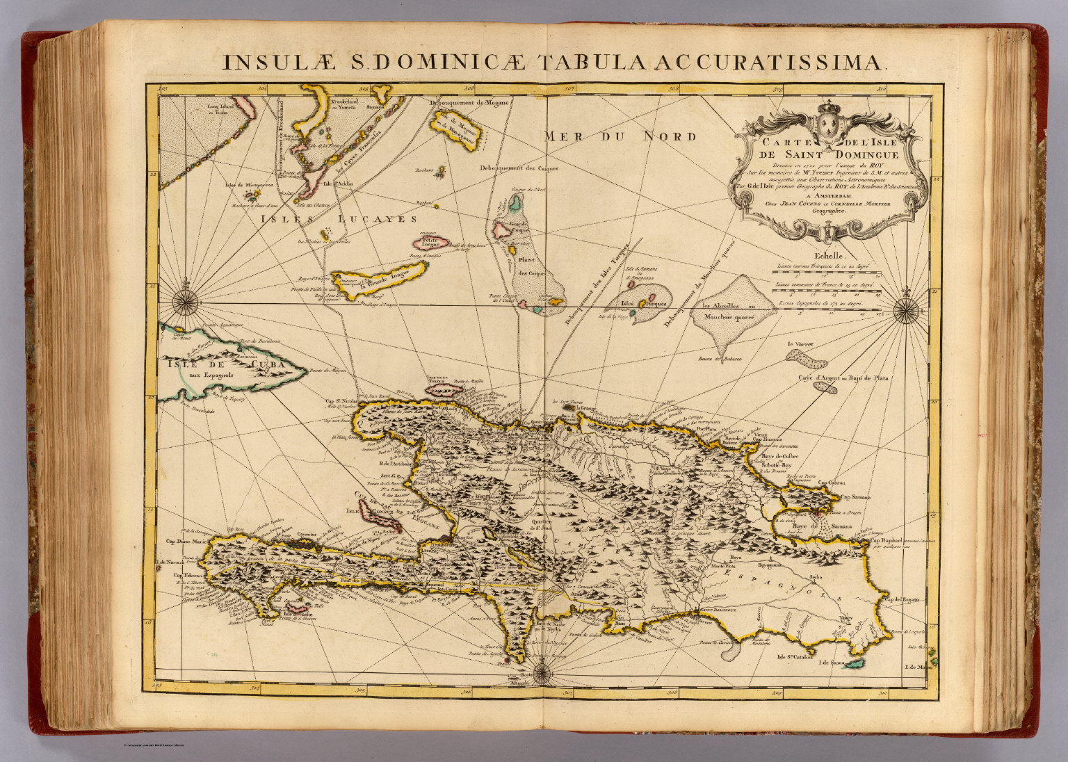
14. This map is awesome. What type of projection is it? What type of map is it (thematic, physical, etc.)? Most importantly, what information does the map tell you about European exploration into the western hemisphere? Was Columbus the first European to arrive? If not, who was, and where did he/she land (present day ____________)?
February 3-4, 2014
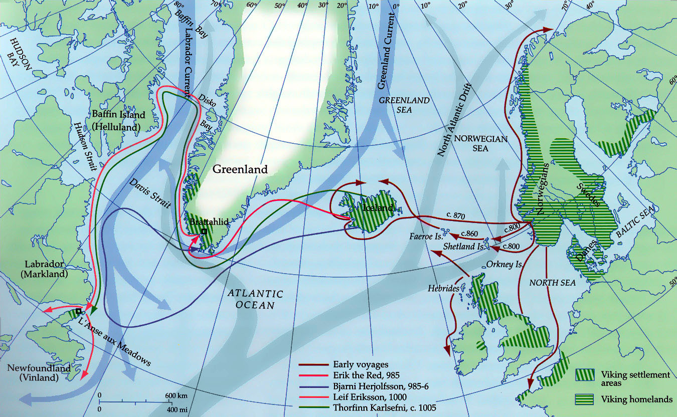
15. Describe a reason that the Vikings may not have "settled" in Canada like other European explorers hundreds of years later. Silly answers do not count.
February 6-7, 2014
16. Go here and learn the continents.
February 10, 2014
17. Click here.
February 11-12, 2014
18. List at least three (3) ways in which immigration has influenced the culture of the United States.
February 12-13, 2014
19. Why is Latin America called "Latin America", do you think? If you're curious, you're more than welcome to look this one up.
February 14, 2014 (oh snap, Valentime's, y'all!)
20. From looking at this map, list the five most densely populated countries in South America.
February 18-19, 2014
21. What is the large island in the bottom half of this map? How can you tell? (must answer both parts)
February 20, 2014
22. Why is the eastern part of Arkansas a darker shade of green, in this map? List two reasons for this (and don't put "because nobody lives there/it's rural").
February 21-24, 2014
23. Click here. Ha. Now Click here. What area of Arkansas had the highest population increase from 2000-2010? What area of Arkansas lost the most population from 2000-2010?
February 24-25, 2014
24. According to this editorial from last year in the New York Times, list some ways in which NAFTA has affected Mexico's economy? Also, trace NAFTA's impact on Mexican immigration to the U.S. You have 15 minutes to do this. Make your answer a well-constructed paragraph.
February 26, 2014
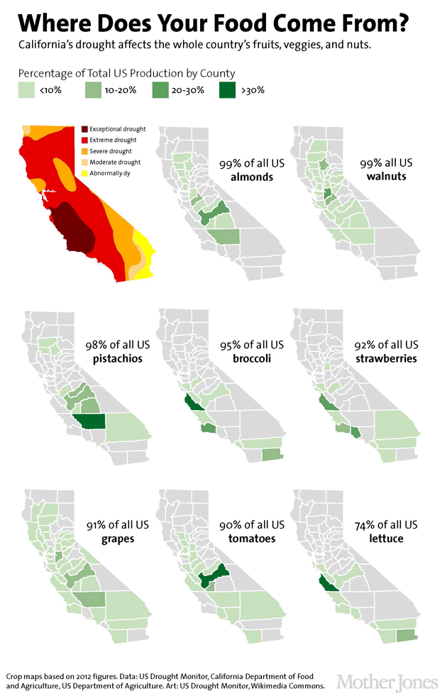
25. According to this map, which Californian crops are being damaged by "Exceptional" and "Extreme" drought?
February 27-28, 2014
26. What is mariachi music in Mexico? What is the history of it? Does it fit into our already-discussed framework of the rural/urban division in Mexico? How? Must answer all questions to receive credit.
March 5, 2014
27. News: Your test will be on Friday, March 7. 2nd Period, you will have today's class period only before your test on Friday. 4th/5th Periods, you will have today's class period and Thursday's class period before your test on Friday. Plan accordingly for your studying. Today's Daily Spark: Write a well-structured and well-planned essay that follows this prompt, "Detail some of the struggles faced after the countries of South America gained their independence from their European colonizers." Any information that is not from your book needs to be properly cited. Your essay can be as long or as short as you desire, but the prompt needs to be fully covered. Also, some of you are getting dangerously close to plagiarism, please be careful. Remember three things: 1) Use academic writing, 2) Actually read your paper when you finish to check for instances of non-academic writing, and 3) Most of you have figured out that time-based activities are as much about planning, organization, and time-management than they are about the actual assignment. You have until the end of class to finish. If you finish with time remaining in class, sit quietly.
March 6, 2014
28. Just to demonstrate how important Arkansas is to U.S. rice production, look at this. What are the top three states in rice production in the U.S.?
March 7, 2014
29. 2nd Period, your test will begin at 10:05am. 4th Period, your test will begin at 1:25pm. 5th Period, report to the Health Room in the gym.
March 10, 2014
30. You are the chosen class. You will video chat with a group of 10th graders in Costa Rica, beginning at about 1:25pm. Scramble to furiously jot down questions you have for them. Can be cultural, geographical, scientific, population, etc. Quick, now!
March 11, 2014
31. Obviously, I am out today. Your assignment is this: Find the oldest and most accurate map of the world, then email me the link and a description of it. After you are finished, you may study for your other classes.
March 12, 2014
32. Would this .gif have come in handy in the last three weeks? Yes or no? Sorry, I just found it. Also, about (that means ROUGHLY) when did the Latin American countries begin to gain their independence?
March 13-14, 2014
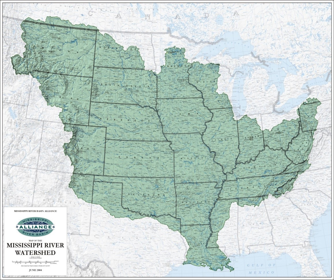
33. From looking at this map of the Mississippi River watershed in the United States, answer the following questions: 1) In your own words (you can look it up, though), what is a "watershed"? 2) LIST the states that are completely in the Mississippi River watershed.
March 14-17, 2014
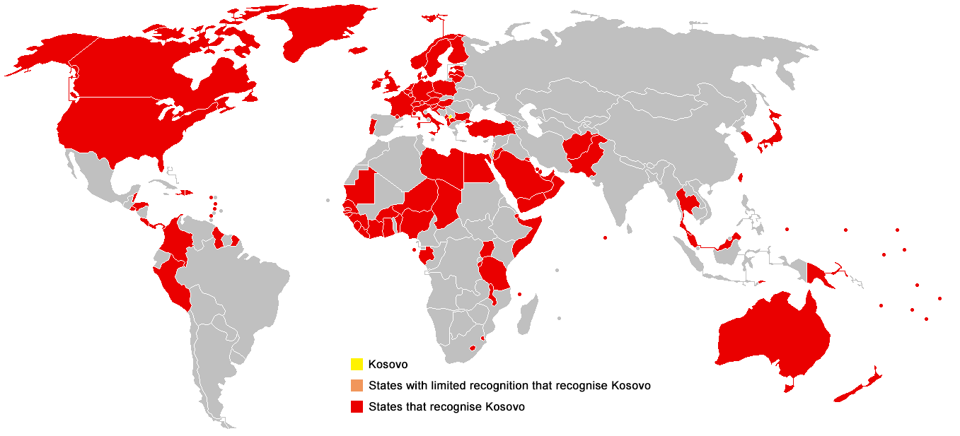
34. From studying this map, list six European countries, one Asian country, and two countries in the western hemisphere that do not recognize Kosovo as an independent nation.
March 18-20, 2014
35. Study for your map quiz. It will begin seven minutes after the start of class. When finished with the map quiz, use these websites (link, link, link, and Link) to answer the following questions and email them to me:
1) List a defining physical characteristic for the Western Uplands, the Alpine Mountains, the Central Uplands, and the Northern European Plain.
2) Mining and drilling are large parts of European natural resource collection. List describe a purpose for the five most mined elements in Europe.
3) Which unassuming part of Europe is emerging as a leader in software and information technology?
4) NatGeo claims that Europe has "arguably the highest standard of living in the world." What does "standard of living" mean? Can you see any potential problems with assigning countries a "high" or "low" standard of living grade (biases, traditional agricultural societies, etc.)? This may require a small amount of research outside of these websites.
5) Using the CIA World FactBook, pick two countries and list all of their natural resources.
6) Peruse/browse the CIA World FactBook a little, it can and will be quite useful for your project. Do this with any remaining time until the end of class.
7) Why are you looking here? You're supposed to be browsing the CIA World FactBook. While you're here, here's some updated information for you. Russia has officially annexed the Crimean Peninsula. You all failed your map quizzes! In all seriousness, I hope you remember the day that you took your map quiz, answered a question, and neither you nor your teacher knew if it was right or wrong.
*How about a little life pro tip for today? PC users can press "ctrl+f" to search for needles in haystacks on webpages. You'll thank me when you get to college.
March 21, 2014
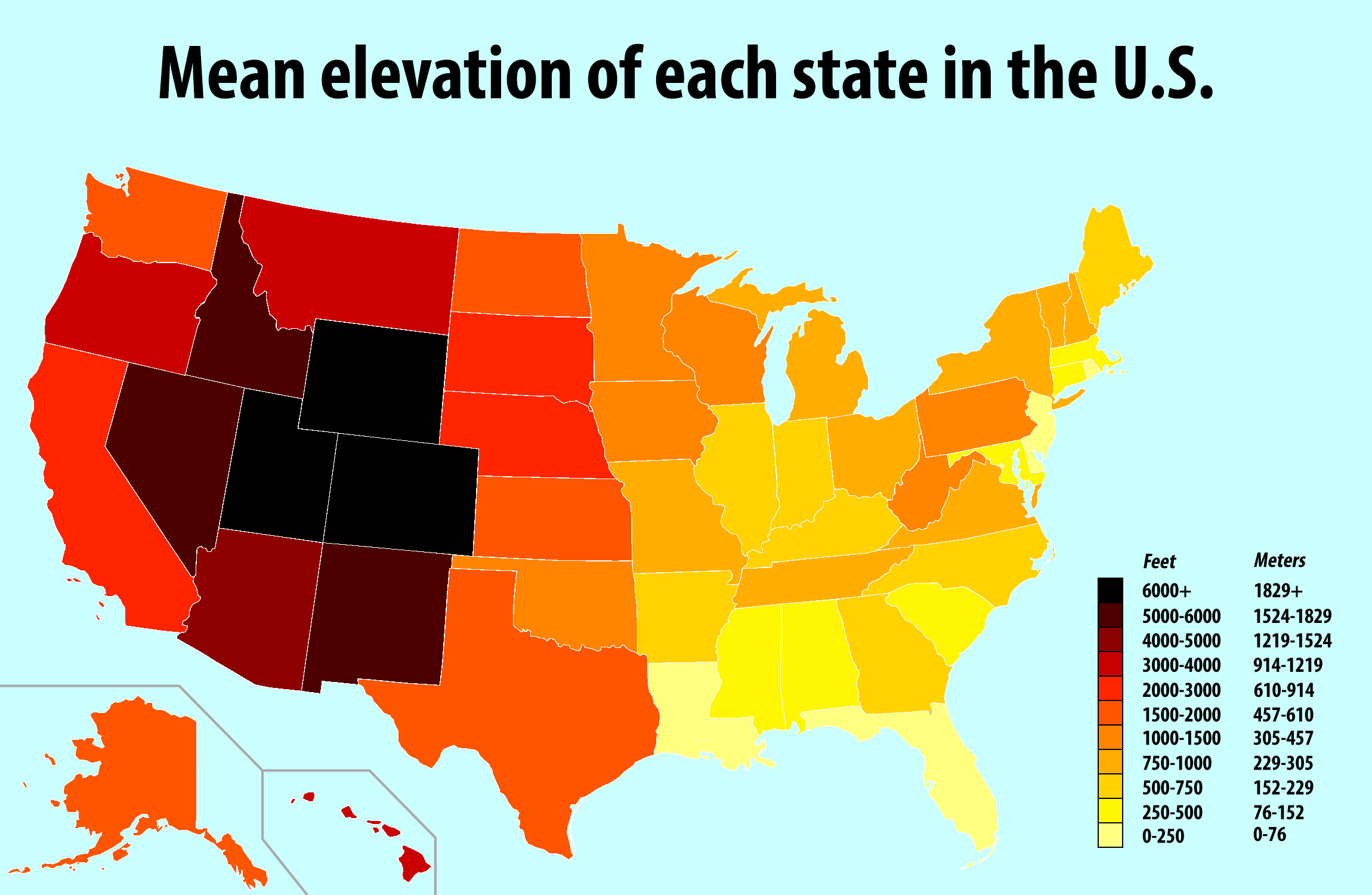
36. According to this map, which three states have the highest mean elevation? Which three have the lowest? What is Arkansas's mean elevation? Which has a higher mean elevation: Hawai'i or Alaska? Accurately describe where the highest mean elevation is in the U.S.
*Due to popular demand, here is the Google cheatsheet.
March 31-April 1, 2014
37. First, due to a misunderstanding of the schedule, your project (and presentations) are due on Thursday, April 3, 2014, during your class period for that day. Second, here be ye Sperk: Take a look at this satellite image. Would you suppose it to be real or fake? If you believe it is fake, why? If you believe that it is real, what would those winds be called?
*And because one of you asked on the Friday before Spring Break, here are more Google tricks: To search only for .pdf documents, type in "filesearch:pdf (insert search term)". To reverse image search, simply right-click any image and then type "s". You're welcome.
April 1-2, 2014
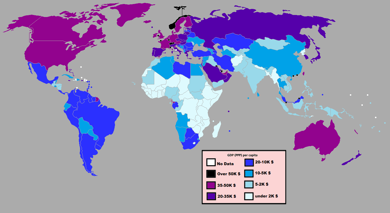
38. According to this map, what are the top five countries in the world, in terms of GDP?
April 3-4, 2014.
39. Yeah, right.
April 7, 2014
40. What is a compass rose?
April 8, 2014
41. According to a study by NPR recently, this is where Americans think Ukraine is. Ponder its sadness. This is your Daily Spark for today.
April 9-10, 2014
42. Brush up on your landforms of Europe with a friend.
April 15, 2014
43. Find a partner and play ten rounds of GeoGuessr. It drops you on a random place on Earth, your job is to use context clues and geographical skills to guess exactly where you are at. Ten rounds. Don't ask about anything else.
April 17, 2014
44. Read these two sources here and here. What is the subject of these articles? Where do these sources get their information from? Are these reliable, do you think? If not, why not? Are they recent? Are they American? What do you think the U.S/Canada/Mexico can do about Asia (specifically China) and their air pollution problem? Make sure you answer all questions. You have less than 15 minutes to complete.
*5th Period - When you get done with the Daily Spark, study the political boundaries of East Asia (Unit 9 in your book).
April 21-22, 2014
45. This is almost geography-related. Using the link here, when is it estimated that the Earth will cease to exist? When will buildings begin to decay? When will Chernobyl finally be able to be deemed "safe" from radiation? You will need to zoom in, probably.
April 22-23, 2014
46. In honor of Earth Day, here's this. Also, according to this thematic map, where does the U.S. rank (generalize it) in terms of women's participation in government (elected officials, etc.)? How does East Asia compare with Western Europe?
April 24, 2014
47. First, with your Daily Spark, send me the URLs of the videos you watched. I’ll check to see if any Central Arkansas IP addresses have accessed those pages in the previous 24 hours.
Second, President Obama is in East Asia right now. Watch this short video and then read this report. What is one topic of geographical importance that President Obama is attempting to tackle while in East Asia? Which countries are involved in the dispute? They article doesn't explicitly say, but why do you think the nations are involved in the dispute? This is an extended Daily Spark and you'll have 15-18 minutes to complete it. (That's a three minute video, a five minute article, and seven to ten minutes of writing)
April 25-28, 2014
48. Our next Unit Exam will be on May 5 or May 6. Spark: This may take a small amount of research. How many languages are spoken in the six countries of East Asia? Your classwork for today is as follows:
- Crack open your textbook to Chapter 27, Section 1 (China).
- For each part of Section 1 ("Population Patterns", "History and Government", and "Culture"), make a bullet-pointed list of three to ten key points per part. Some parts are larger than others, thus the wide discrepancy in the amount of key points. You may work with ONE partner, but each person needs to produce their own work. This will go in your notes and are not to be turned in.
- Make sure to summarize your notes really well.
- If you finish Section 1 and summarizing your notes, get your notebook in order until the class period is over.
- If you finish all of that and still have time remaining in class, figure out a way to assist those in Central Arkansas affected by yesterday's tornadoes.
April 29, 2014
49. What is an export? According to this map, what is China's top export? What is Japan's top export? What is South Korea's top export?
April 30-May 1, 2014
50. Without looking it up, what do you think China's top three agricultural exports are?
May 1, 2014
51. Don't forget about your test on Monday. For your Daily Spark today, you'll have about 20-25 minutes to complete it (possibly more, if you get to work on time). In 1958, the Chinese government enacted the "Great Leap Forward." What did the campaign have to do with Chinese agriculture? How did it fare? In the 1980s, what did the Chinese government do to reverse these policies? How did these fare? Construct your answer in an essay of no fewer than two paragraphs. Don't forget, if you use anything other than your textbook, you'll need to reference it in your answer or make a bibliography. If you use them, MAKE SURE YOUR SOURCES ARE RELIABLE AND VALID.
May 5, 2014
52. Your test will begin in 7-10 minutes.
May 6-7, 2014
53. Two things: Check on your grades in this class. Also, write another haiku. The theme: physical geography.
May 8, 2014
54. With a partner, quiz each other on some of those definitions on RA2 and RA3. You will have about 10 minutes to do this.
May 9-12, 2014
55. Using any writing utensil and any standard piece of paper (at least 8.5"x11"), draw a giant landform that depicts one term from each column of RA2 and RA3 (4 total). Do not mimic the landform already drawn at the top of RA2 or RA3. You will have about 15 minutes (maybe 20) to get this done. When finished, place on counter in front of General Bill Murray.
May 12-13, 2014
56. Using any writing utensil and any standard piece of paper (at least 8.5"x11"), draw a giant landform that depicts two terms from each column of RA2 and RA3 (8 total). Do not choose terms that you drew for the last Daily Spark. Do not mimic the landform already drawn at the top of RA2 or RA3. You will have about 15 minutes (maybe 20) to get this done. When finished, place on counter in front of General Bill Murray.
May 14, 2014
57. Reading Day? Reading Day. Rules are as follows: Do not get up , do not be loud.
May 15, 2014
58. Reading Day. If you wish, you may partner with a classmate and study. Rules still stand: Don't be up a lot, don't be loud. E-Mail me your studying questions, I'll try to get answers back to you.
May 19, 2014
59. Reading Day. See me for all questions. Your test is tomorrow morning.
1. Your Daily Sparks will one change for this semester. On occasion (often, actually), you'll have a link to a map that you'll need to answer some questions about. Most of these Daily Sparks (with the maps) are graded for accuracy, so really make sure you're correct and that you answer all questions using any available means. For your first Daily Spark of 2014, we'll start with this 1972 map of Arkansas. List a county on the northern border of the state, a county on the southern border of the state, a county on the western border of the state, and a county on the eastern border of the state.
January 7-8, 2014
2. Our class calendar for second semester is now posted under the Calendar tab. Also, for those of you that find yourselves frequently bored and wishing to learn more about examples of U.S. citizens' interpretations of civil disobedience in the "modern" era of U.S. history, here is a fascinating interview. When was the last time you used a map? What was it for? Were you successful in your interpretation of the map for its purposes? Do not include any instances of GPS usage.
January 9, 2014
3. Take a look at this map. Who do you think made it? What is it? What do you think it was for? Why are the modern North/South American continents superimposed into the background, do you think?
January 10-13, 2014
4. Is this map political, physical, or thematic? What do you think this map is about?
January 13-14, 2014
5. According to this map, how many counties in Arkansas have a median household income of $52,000 or above? How many counties on the Texas border with Mexico DO NOT have a median household income of more than $35,000? Lastly, see if you can find these prominent urban areas, even without any indicators on this map: Chicago (IL), Dallas (TX), Houston (TX), Nashville (TN), Atlanta (GA), Washington (DC), San Francisco (CA).
January 15, 2014
6. In 2-3 sentences (not 1), how does Earth axis and tilt affect the seasons in Arkansas?
January 16-17, 2014
7. Study this map of Native American language families before the arrival of Europeans. What are the three most widely used, in terms of land area, language families?
January 21, 2014
8. Take a look at the picture on page 79 of your textbook. How old do you think that phone is?
January 22-23, 2014
9. This is a map of what the Earth may look like after global warming melts a ton of polar ice. Would Little Rock be under water? What about Pine Bluff? If you cannot tell, find another map with those cities on it and compare the two.
January 23-24, 2014
10. Study up, son! Your test will start in 6 minutes.
January 27, 2014
11. Make one decision and choose between this link and this link. You can only pick one, do not go back and choose the other. Don't be wise and try to tip off your friends/classmates about which link is which, I will be changing them (...or will I?). After you've chosen, answer this: In your own words, what do you see? What is it? Work on your writing efficiency in your Daily Sparks. Some of your Daily Sparks are getting quite lazy.
January 28-29, 2014
12. Use words to describe the following areas on this map: 1) Eastern Delta, 2) Ozark Mountains, 3) Ouachita Mountains.
January 30, 2014
13. Study for map quiz. No mercy on those that do not.
January 31-February 3, 2014
14. This map is awesome. What type of projection is it? What type of map is it (thematic, physical, etc.)? Most importantly, what information does the map tell you about European exploration into the western hemisphere? Was Columbus the first European to arrive? If not, who was, and where did he/she land (present day ____________)?
February 3-4, 2014
15. Describe a reason that the Vikings may not have "settled" in Canada like other European explorers hundreds of years later. Silly answers do not count.
February 6-7, 2014
16. Go here and learn the continents.
February 10, 2014
17. Click here.
February 11-12, 2014
18. List at least three (3) ways in which immigration has influenced the culture of the United States.
February 12-13, 2014
19. Why is Latin America called "Latin America", do you think? If you're curious, you're more than welcome to look this one up.
February 14, 2014 (oh snap, Valentime's, y'all!)
20. From looking at this map, list the five most densely populated countries in South America.
February 18-19, 2014
21. What is the large island in the bottom half of this map? How can you tell? (must answer both parts)
February 20, 2014
22. Why is the eastern part of Arkansas a darker shade of green, in this map? List two reasons for this (and don't put "because nobody lives there/it's rural").
February 21-24, 2014
23. Click here. Ha. Now Click here. What area of Arkansas had the highest population increase from 2000-2010? What area of Arkansas lost the most population from 2000-2010?
February 24-25, 2014
24. According to this editorial from last year in the New York Times, list some ways in which NAFTA has affected Mexico's economy? Also, trace NAFTA's impact on Mexican immigration to the U.S. You have 15 minutes to do this. Make your answer a well-constructed paragraph.
February 26, 2014
25. According to this map, which Californian crops are being damaged by "Exceptional" and "Extreme" drought?
February 27-28, 2014
26. What is mariachi music in Mexico? What is the history of it? Does it fit into our already-discussed framework of the rural/urban division in Mexico? How? Must answer all questions to receive credit.
March 5, 2014
27. News: Your test will be on Friday, March 7. 2nd Period, you will have today's class period only before your test on Friday. 4th/5th Periods, you will have today's class period and Thursday's class period before your test on Friday. Plan accordingly for your studying. Today's Daily Spark: Write a well-structured and well-planned essay that follows this prompt, "Detail some of the struggles faced after the countries of South America gained their independence from their European colonizers." Any information that is not from your book needs to be properly cited. Your essay can be as long or as short as you desire, but the prompt needs to be fully covered. Also, some of you are getting dangerously close to plagiarism, please be careful. Remember three things: 1) Use academic writing, 2) Actually read your paper when you finish to check for instances of non-academic writing, and 3) Most of you have figured out that time-based activities are as much about planning, organization, and time-management than they are about the actual assignment. You have until the end of class to finish. If you finish with time remaining in class, sit quietly.
March 6, 2014
28. Just to demonstrate how important Arkansas is to U.S. rice production, look at this. What are the top three states in rice production in the U.S.?
March 7, 2014
29. 2nd Period, your test will begin at 10:05am. 4th Period, your test will begin at 1:25pm. 5th Period, report to the Health Room in the gym.
March 10, 2014
30. You are the chosen class. You will video chat with a group of 10th graders in Costa Rica, beginning at about 1:25pm. Scramble to furiously jot down questions you have for them. Can be cultural, geographical, scientific, population, etc. Quick, now!
March 11, 2014
31. Obviously, I am out today. Your assignment is this: Find the oldest and most accurate map of the world, then email me the link and a description of it. After you are finished, you may study for your other classes.
March 12, 2014
32. Would this .gif have come in handy in the last three weeks? Yes or no? Sorry, I just found it. Also, about (that means ROUGHLY) when did the Latin American countries begin to gain their independence?
March 13-14, 2014
33. From looking at this map of the Mississippi River watershed in the United States, answer the following questions: 1) In your own words (you can look it up, though), what is a "watershed"? 2) LIST the states that are completely in the Mississippi River watershed.
March 14-17, 2014
34. From studying this map, list six European countries, one Asian country, and two countries in the western hemisphere that do not recognize Kosovo as an independent nation.
March 18-20, 2014
35. Study for your map quiz. It will begin seven minutes after the start of class. When finished with the map quiz, use these websites (link, link, link, and Link) to answer the following questions and email them to me:
1) List a defining physical characteristic for the Western Uplands, the Alpine Mountains, the Central Uplands, and the Northern European Plain.
2) Mining and drilling are large parts of European natural resource collection. List describe a purpose for the five most mined elements in Europe.
3) Which unassuming part of Europe is emerging as a leader in software and information technology?
4) NatGeo claims that Europe has "arguably the highest standard of living in the world." What does "standard of living" mean? Can you see any potential problems with assigning countries a "high" or "low" standard of living grade (biases, traditional agricultural societies, etc.)? This may require a small amount of research outside of these websites.
5) Using the CIA World FactBook, pick two countries and list all of their natural resources.
6) Peruse/browse the CIA World FactBook a little, it can and will be quite useful for your project. Do this with any remaining time until the end of class.
7) Why are you looking here? You're supposed to be browsing the CIA World FactBook. While you're here, here's some updated information for you. Russia has officially annexed the Crimean Peninsula. You all failed your map quizzes! In all seriousness, I hope you remember the day that you took your map quiz, answered a question, and neither you nor your teacher knew if it was right or wrong.
*How about a little life pro tip for today? PC users can press "ctrl+f" to search for needles in haystacks on webpages. You'll thank me when you get to college.
March 21, 2014
36. According to this map, which three states have the highest mean elevation? Which three have the lowest? What is Arkansas's mean elevation? Which has a higher mean elevation: Hawai'i or Alaska? Accurately describe where the highest mean elevation is in the U.S.
*Due to popular demand, here is the Google cheatsheet.
March 31-April 1, 2014
37. First, due to a misunderstanding of the schedule, your project (and presentations) are due on Thursday, April 3, 2014, during your class period for that day. Second, here be ye Sperk: Take a look at this satellite image. Would you suppose it to be real or fake? If you believe it is fake, why? If you believe that it is real, what would those winds be called?
*And because one of you asked on the Friday before Spring Break, here are more Google tricks: To search only for .pdf documents, type in "filesearch:pdf (insert search term)". To reverse image search, simply right-click any image and then type "s". You're welcome.
April 1-2, 2014
38. According to this map, what are the top five countries in the world, in terms of GDP?
April 3-4, 2014.
39. Yeah, right.
April 7, 2014
40. What is a compass rose?
April 8, 2014
41. According to a study by NPR recently, this is where Americans think Ukraine is. Ponder its sadness. This is your Daily Spark for today.
April 9-10, 2014
42. Brush up on your landforms of Europe with a friend.
April 15, 2014
43. Find a partner and play ten rounds of GeoGuessr. It drops you on a random place on Earth, your job is to use context clues and geographical skills to guess exactly where you are at. Ten rounds. Don't ask about anything else.
April 17, 2014
44. Read these two sources here and here. What is the subject of these articles? Where do these sources get their information from? Are these reliable, do you think? If not, why not? Are they recent? Are they American? What do you think the U.S/Canada/Mexico can do about Asia (specifically China) and their air pollution problem? Make sure you answer all questions. You have less than 15 minutes to complete.
*5th Period - When you get done with the Daily Spark, study the political boundaries of East Asia (Unit 9 in your book).
April 21-22, 2014
45. This is almost geography-related. Using the link here, when is it estimated that the Earth will cease to exist? When will buildings begin to decay? When will Chernobyl finally be able to be deemed "safe" from radiation? You will need to zoom in, probably.
April 22-23, 2014
46. In honor of Earth Day, here's this. Also, according to this thematic map, where does the U.S. rank (generalize it) in terms of women's participation in government (elected officials, etc.)? How does East Asia compare with Western Europe?
April 24, 2014
47. First, with your Daily Spark, send me the URLs of the videos you watched. I’ll check to see if any Central Arkansas IP addresses have accessed those pages in the previous 24 hours.
Second, President Obama is in East Asia right now. Watch this short video and then read this report. What is one topic of geographical importance that President Obama is attempting to tackle while in East Asia? Which countries are involved in the dispute? They article doesn't explicitly say, but why do you think the nations are involved in the dispute? This is an extended Daily Spark and you'll have 15-18 minutes to complete it. (That's a three minute video, a five minute article, and seven to ten minutes of writing)
April 25-28, 2014
48. Our next Unit Exam will be on May 5 or May 6. Spark: This may take a small amount of research. How many languages are spoken in the six countries of East Asia? Your classwork for today is as follows:
- Crack open your textbook to Chapter 27, Section 1 (China).
- For each part of Section 1 ("Population Patterns", "History and Government", and "Culture"), make a bullet-pointed list of three to ten key points per part. Some parts are larger than others, thus the wide discrepancy in the amount of key points. You may work with ONE partner, but each person needs to produce their own work. This will go in your notes and are not to be turned in.
- Make sure to summarize your notes really well.
- If you finish Section 1 and summarizing your notes, get your notebook in order until the class period is over.
- If you finish all of that and still have time remaining in class, figure out a way to assist those in Central Arkansas affected by yesterday's tornadoes.
April 29, 2014
49. What is an export? According to this map, what is China's top export? What is Japan's top export? What is South Korea's top export?
April 30-May 1, 2014
50. Without looking it up, what do you think China's top three agricultural exports are?
May 1, 2014
51. Don't forget about your test on Monday. For your Daily Spark today, you'll have about 20-25 minutes to complete it (possibly more, if you get to work on time). In 1958, the Chinese government enacted the "Great Leap Forward." What did the campaign have to do with Chinese agriculture? How did it fare? In the 1980s, what did the Chinese government do to reverse these policies? How did these fare? Construct your answer in an essay of no fewer than two paragraphs. Don't forget, if you use anything other than your textbook, you'll need to reference it in your answer or make a bibliography. If you use them, MAKE SURE YOUR SOURCES ARE RELIABLE AND VALID.
May 5, 2014
52. Your test will begin in 7-10 minutes.
May 6-7, 2014
53. Two things: Check on your grades in this class. Also, write another haiku. The theme: physical geography.
May 8, 2014
54. With a partner, quiz each other on some of those definitions on RA2 and RA3. You will have about 10 minutes to do this.
May 9-12, 2014
55. Using any writing utensil and any standard piece of paper (at least 8.5"x11"), draw a giant landform that depicts one term from each column of RA2 and RA3 (4 total). Do not mimic the landform already drawn at the top of RA2 or RA3. You will have about 15 minutes (maybe 20) to get this done. When finished, place on counter in front of General Bill Murray.
May 12-13, 2014
56. Using any writing utensil and any standard piece of paper (at least 8.5"x11"), draw a giant landform that depicts two terms from each column of RA2 and RA3 (8 total). Do not choose terms that you drew for the last Daily Spark. Do not mimic the landform already drawn at the top of RA2 or RA3. You will have about 15 minutes (maybe 20) to get this done. When finished, place on counter in front of General Bill Murray.
May 14, 2014
57. Reading Day? Reading Day. Rules are as follows: Do not get up , do not be loud.
May 15, 2014
58. Reading Day. If you wish, you may partner with a classmate and study. Rules still stand: Don't be up a lot, don't be loud. E-Mail me your studying questions, I'll try to get answers back to you.
May 19, 2014
59. Reading Day. See me for all questions. Your test is tomorrow morning.
***E-Mail Coach Marsh here***
